Storm Claudio: Northern England to be hit by severe rain and wind gusts of up to 65mph, Met Office says
and live on Freeview channel 276
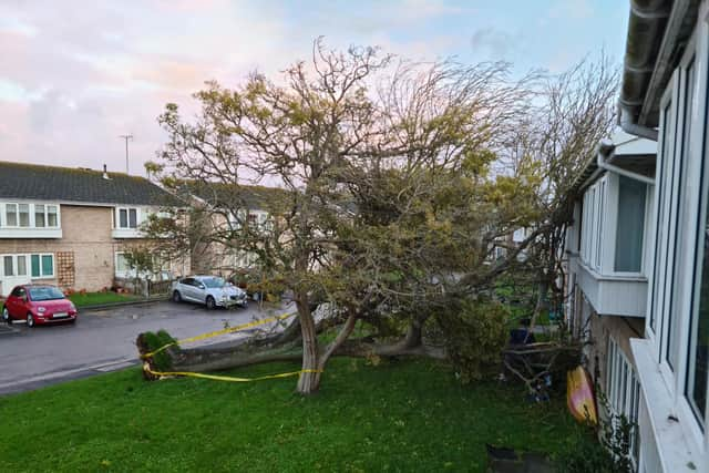
After severe winds pounded the south of England this morning (November 1), Storm Claudio is expected to deliver torrential rain and winds of up to 65 miles per hour, prompting the Met Office to issue a second yellow weather warning.
In the early hours of Tuesday, the south, particularly Portsmouth and Brighton, was severely hit by strong winds that lasted until around 8am. Meanwhile, another yellow warning has been issued from 7am to 6pm on Wednesday (November 2), bringing the risk of floods and travel disruption as well as strong winds and heavy rain.
Advertisement
Advertisement
Storm Claudio, which has been named by the French Meteorological Office, has reportedly delivered the strongest winds from northern France to much of the southern coast of England in the early hours of Tuesday, with some isolated coastal regions experiencing gusts in excess of 70 miles per hour.
Deputy Chief Meteorologist Steven Keates said: “Within the warning area, gusts are expected to be between 55 and 65mph. This is associated with low pressure moving towards the northwest of the UK, which is bringing with it some heavy rain on Wednesday, especially across parts of southwest Scotland, Cumbria and western Wales, although much of the UK will see some rain through the day. In addition to high winds in the warning area, many parts of the UK will experience strong and gusty winds, at least for a time, during Wednesday.”
The Met Office said after Storm Claudio moves eastwards early on Tuesday, what’s left behind is a showery day for much of the UK, with Wales and areas in southern and central England likely to see the most frequent of showers.
Met Office Chief Meteorologist Neil Armstrong said: “The biggest impacts from Storm Claudio are expected in northern France, which is why it has been named as a system by Météo-France. What it means for us in the UK is for some high winds to be possible along much of the southern coast of England. Some isolated and especially exposed coastal areas could see gusts in excess of 70mph, while much of the warning area will see gusts of between 50 and 60mph.”
Met Office UK 5-day weather forecast
Today (November 1)
Advertisement
Advertisement
Early rain, heavy at times, over Scotland and northern England clears northwards leaving brighter conditions, but also some showers, mainly in the west. Elsewhere, changeable with sunny spells and heavy, blustery showers. Windy, especially in southern coastal areas.
Tonight:
Further showers, heavy at times, this evening. Showers then become mostly confined to western areas during the early hours. Colder than last night.


Wednesday (November 2)
Bright start for many areas. Rain, heavy at times, developing in the west during the morning then moves eastwards during the afternoon. Becoming windy, especially in western coastal areas.
Outlook for Thursday to Saturday (November 3 to November 5)
Changeable with spells of wet and windy weather interspersed with drier, brighter interludes. Windy at times with gales along some coasts. Temperatures close to average.
